
The Envisat Cal/Val Data Centre
View/
Discipline
Physical sciences
Subject
geophysical techniques
geophysical signal processing
terrain mapping
atmospheric techniques
oceanographic techniques
remote sensing
geophysical measurement technique
land surface
terrain mapping
atmosphere
ocean
meteorology
satellite remote sensing
Envisat
ENVISAT-1
Envisat Cal/Val data centre
calibration
validation
European Space Agency
NADIR
visible
IR
infrared
UV
ultraviolet
multispectral remote sensing
data processing
ESA
MIPAS
GOMOS
SCIAMACHY
MERIS
AATSR
Instruments
Satellites
Performance evaluation
Multispectral imaging
Remote sensing
Information retrieval
Data mining
Geophysical measurements
Data engineering
Calibration
Audience
Scientific
Date
2002Metadata
Show full item recordDescription
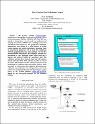
The Envisat satellite (envisat.esa.int), launched on 1 March 2002, carries ten instruments. Three of the instruments, MIPAS, GOMOS, SCIAMACHY, are aimed at atmospheric research and two multi-spectral imaging instruments, MERIS and AATSR perform land and marine observations. For geophysical validation, independent observations by a large number of in-situ, remote-sensing and satellite instruments, including those on space-borne platforms, will be used for comparison with the geophysical Envisat data products. For the five aforementioned instruments, the validation activities are performed by two dedicated teams which both use a storage and retrieval facility for correlative data. The validation activities have begun in April and will continue for the entire duration of the mission. In order to extract maximum information from the coincident measurements performed for validation, these correlative data are made accessible to all scientists and engineers performing the validation and calibration. For this purpose, a new data centre was commissioned by the European Space Agency (ESA) at the NADIR database (nadir.nilu.no/calval), hosted by the Norwegian Institute for Air Research (NILU).
Citation
Koopman, R.M.; Bojkov, B.R.; De Mazière, M. (2002). The Envisat Cal/Val Data Centre. , IEEE International Geoscience and Remote Sensing Symposium, 24-28 June 2002, Toronto, Ontario, Canada, Vol. 1, 258-260, DOI: 10.1109/IGARSS.2002.1025005.Identifiers
Type
Conference
Peer-Review
No
Language
eng